


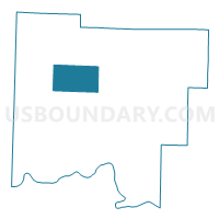
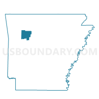
Low Gap Voting District, Johnson County, Arkansas
About
Outline

Summary
| Unique Area Identifier | 526996 |
| Name | Low Gap Voting District |
| County | Johnson County |
| State | Arkansas |
| Area (square miles) | 27.74 |
| Land Area (square miles) | 27.71 |
| Water Area (square miles) | 0.03 |
| % of Land Area | 99.90 |
| % of Water Area | 0.10 |
| Latitude of the Internal Point | 35.60586100 |
| Longtitude of the Internal Point | -93.53529670 |
Maps

Graphs
Select a template below for downloading or customizing gragh for Low Gap Voting District, Johnson County, Arkansas


Neighbors
Neighoring Voting District (by Name) Neighboring Voting District on the Map
- Batson Voting District, Johnson County, AR
- Dickerson Voting District, Johnson County, AR
- Horsehead Voting District, Johnson County, AR
- King Voting District, Johnson County, AR
- Mulberry Voting District, Johnson County, AR
- Red Lick Voting District, Johnson County, AR
- Sherman Voting District, Johnson County, AR
Top 10 Neighboring County Subdivision (by Population) Neighboring County Subdivision on the Map
- Red Lick township, Johnson County, AR (1,232)
- King township, Johnson County, AR (1,227)
- Horsehead township, Johnson County, AR (761)
- Sherman township, Johnson County, AR (356)
- Batson township, Johnson County, AR (219)
- Mulberry township, Johnson County, AR (170)
- Low Gap township, Johnson County, AR (136)
- Dickerson-Hill township, Johnson County, AR (104)
Top 10 Neighboring Unified School District (by Population) Neighboring Unified School District on the Map
- Clarksville School District, AR (14,088)
- Lamar School District, AR (6,860)
- Jasper School District, AR (5,912)